
Multiple homes were damaged and at least one water rescue was underway as a large and dangerous storm system continued its push through Southern California on Monday.
The slow-moving atmospheric river parked itself over the Los Angeles metropolitan area late Sunday afternoon, jump-starting what the National Weather Service called “one of the most dramatic weather days in recent memory.” By Monday morning, the storm was straddling Los Angeles and Orange counties, where an “ extremely dangerous situation” was unfolding including rushing rivers, downed trees, flooded streets and power outages, as well as landslides in the Hollywood Hills and Santa Monica Mountains.
In the San Fernando Valley, crews were responding to a report of a 6-year-old boy who needed rescue from a wash near Arleta, according to the Los Angeles Fire Department. The boy hadn’t been spotted, but crews were “staged at various rescue points along the waterway to attempt a rescue, and are searching by ground and air,” according to spokesperson Nicholas Prange.
The storm prompted a state of emergency declaration from Gov. Gavin Newsom along with evacuation orders and warnings for residents in and around wildfire burn scars in Sun Valley, Topanga, Juniper Hills and other local areas.
Rainfall totals were continuing to pile up, including 10.28 inches in the Topanga area, 9.84 inches around Bel-Air and 5.3 inches in downtown Los Angeles — with much more on the way, according to Ryan Kittell, a meteorologist with the National Weather Service.
“There’s still a lot of rain to come,” he said. “There’s a lot of rain left.”
The plume of moisture was expected to linger over the greater Los Angeles metropolitan area through Monday night, followed by on-and-off rain Tuesday and possibly even some showers Wednesday, Kittell said.
“It’s definitely declining starting Wednesday,” he said, but “it’s not until after Friday that we get the all-clear.”
The storm was “remarkable and in some ways historic,” said Daniel Swain, a climate scientist with UCLA. He noted that system reached bombogenesis— or “bomb cyclone” — status as it zeroed in on the state Sunday, indicating a sustained drop in pressure and a rapid strengthening.
“The concern right now in Southern California is that the rain and the atmospheric river has been stalled, mainly over the same place it has been for the past 18 hours,” Swain said during a briefing Monday.
It is likely that Los Angeles will come close to, or even exceed, an all-time 24-hour rainfall record when all is said and done, he said.
The atmospheric river already smashed several daily rainfall records on Sunday. Downtown Los Angeles received 4.1 inches of rain — breaking the record of 2.55 inches set on Feb. 4, 1927. It was the area’s 10th wettest day since records began in 1877. Santa Barbara Airport broke a daily record with 2.39 inches of rain on Sunday, as did Los Angeles International Airport with 1.76 inches, and Long Beach Airport with 1.5 inches.
The storm packed a wallop across the state, including flooding, water rescues and damaging winds in the San Francisco Bay Area and down the Central Coast. More than half a million people remained without power statewide Monday morning.
But all eyes were on Southern California on Monday, where urgent flash flood warnings remained in effect for portions of San Bernardino, Ventura and Los Angeles counties, including areas around the Santa Monica Mountains and Hollywood Hills.
Some of the worst effects were expected Monday and Tuesday in portions of Orange, Riverside and San Bernardino counties, where “catastrophic and life-threatening flooding” was possible as the storm continued its crawl toward the state’s southern border, the National Weather Service said.
A stretch of Pacific Coast Highway adjacent to the Bolsa Chica Ecological Reserve from Seapoint Street to Warner Avenue remained closed Monday morning. The scenic stretch of Huntington Beach, which often floods during heavy rain, was inundated with water Sunday night, prompting crews to close both directions of the road. It was unclear when it would reopen.
The San Bernardino Mountains could see up to 8 inches of additional rainfall through Tuesday evening, while the mountains of San Diego and Riverside counties could see an additional 4 inches, the NWS said.
“Storms can change quickly, but let me be clear: This storm is a serious weather event,” Los Angeles Mayor Karen Bass said during a news conference Sunday. “This has the potential to be a historic storm — severe winds, thunderstorms, and even brief tornadoes.”
Indeed, many Angelenos awakened Monday to a soggy, muddy mess, including dozens of road closures and delays due to flooding and debris, according to the California Department of Transportation, California Highway Patrol and other agencies.
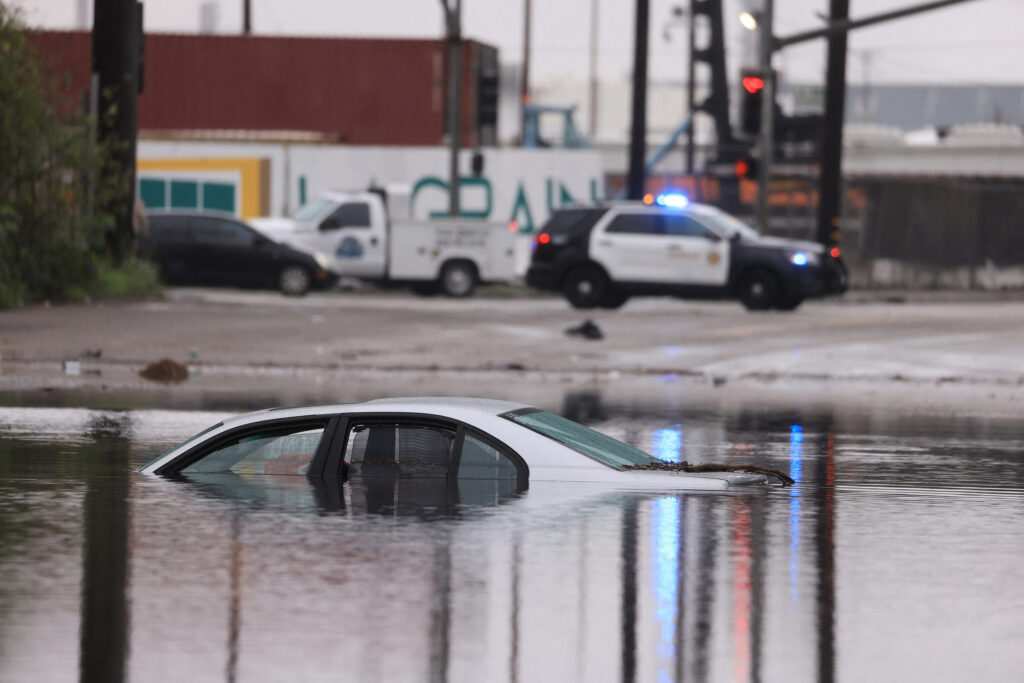
Multiple vehicles were submerged Monday on Piuma Road near Calabasas, and another vehicle was submerged on Balkins Drive in Agoura Hills, according to Los Angeles County sheriff’s officials. Minor debris flows had occurred in Agoura Hills, including one on Cornell Road and one on Eagletown Street. A 10-foot boulder was reported on northbound Malibu Canyon Road about 2 miles north of Pacific Coast Highway.
Some on-ramps and southbound lanes along the 5 Freeway were closed from Burbank to Los Feliz, as was a portion of State Route 23 near Banning Dam in Thousand Oaks, CalTrans said. State Route 33 was closed in both directions between Ojai and Lockwood Valley Road due to mudslides. A video of the area showed chunks of mud and rocks splayed across the road.
At least five homes were significantly damaged in a debris flow Monday morning in the 1900 block of North Beverly Drive in Beverly Crest, said Prange, the LAFD spokesperson. No one was trapped, he said, but about 10 people have been displaced.
Mud was also flowing across the Hollywood Hills, damaging homes and forcing residents to flee. At least two homes were damaged as debris flowed down Lockridge Road near Fryman Canyon in Studio City on Sunday night, and an additional nine homes were evacuated from the area out of concern about additional soil instability. Firefighters evacuated residents from three homes on Boris Drive in Tarzana due to flowing debris.
Topanga Canyon Road was closed for about a mile south of Woodland Hills due to flooding. Meanwhile, a portion of Beverly Glen Drive was blocked by debris, trash cans, mud and rocks — creating significant headaches for residents including Marvin Yasuda, who was rerouted from the area after dropping his kids off at school.
“I just have to go around,” he said in a hurry as he calculated a new route to his home. “It will probably take more than an hour. There is no other street.”
In Long Beach, 19 people were rescued Sunday from the rocks of the breakwater after the mast of a 40-foot boat they were on broke in high winds.
Officials urged Angelenos to stay home if possible. Those who must drive were advised to do so with caution, and to avoid deep water.
However, schools remained open in the Los Angeles area Monday, except for Vinedale Preparatory Academy in Sun Valley, which was affected by mandatory evacuation orders, and Topanga Elementary Charter School in Topanga. Both schools were affected by potentially dangerous hillside conditions. Students and staff at both schools were directed to other campuses for the day.
Santa Barbara County school districts opted to close Monday. Meanwhile, at least seven Cal State campuses — Long Beach, Dominguez Hills, Fullerton, Los Angeles, Northridge, Pomona and San Bernardino— alerted students and staff that classes would move online.
The storm also delivered powerful winds Sunday, including gusts up to 83 mph in the San Gabriel Mountains; 58 mph in Newhall Pass and 45 mph in the western San Fernando Valley.
By Monday, the strong gusts associated with the storm had abated into light southeasterly winds.
But slow, steady rain would continue to pour, Kittell said.
“It’s just a tremendous amount of rain in the last 24 hours,” he added.
___
© 2024 Los Angeles Times
Distributed by Tribune Content Agency, LLC.